Marine Area 2 - Westport/Ocean Shores
Marine Area 2-1 (Willapa Bay) and
Marine Area 2-2 (Grays Harbor)
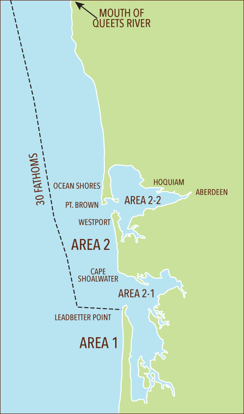
Marine Area 2 Definition: from Leadbetter Point north to the Queets River, excluding Willapa Bay and Grays Harbor.
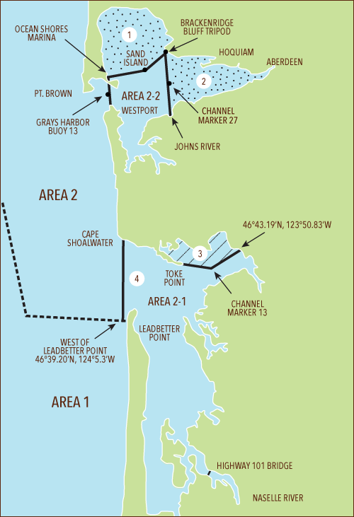
Marine Area 2-1 (Willapa Bay) Definition: east of a line from Leadbetter Point (46°39.20' N, 124° 3.516' W) due west to 46°39.20' N, 124° 5.3' W then due north to the westerly most landfall on Cape Shoalwater (46°44.66' N, 124° 5.3' W).
Marine Area 2-2 (Grays Harbor) Definition: east of a line from the tip of the north jetty to exposed end of the south jetty.


 Humptulips North Bay Fishery
Northerly of a line running from the south end of the eastern jetty at Ocean Shores Marina, then to a fishing boundary marker on Sand Island (46°57.52'N, 124°03.36'W) then to the Tripod Station located at 46°59.12'N, 124°00.72'W on Brackenridge Bluff.
 East Grays Harbor Fishery
Easterly of a projected line from the mouth of Johns River (Hwy. 105 Bridge) to the Tripod Station on Brackenridge Bluff (46°59.12'N, 124°00.72'W) through channel marker 27 (green).
 North River Closure
Aug.1-Sept. 30: closed to salmon angling in waters north of a line from Toke Point channel marker 3 easterly through Willapa Harbor channel marker 13 (green) northeasterly to the power transmission pole located at 46°43.19'N, 123°50.83'W.
 Marine Area 2-1 (Willapa Bay) Definition
Waters east of a line from Leadbetter Point (46°39.20' N, 124° 3.516' W) due west to 46°39.20' N, 124° 5.3' W then due north to the westerly most landfall on Cape Shoalwater (46°44.66' N, 124° 5.3' W).
NOTE: In Areas 2-1 and 2-2, anglers may use either a freshwater, saltwater, or combination license.
HALIBUT and BOTTOMFISH Closure Areas Fishing for HALIBUT and BOTTOMFISH is closed and anglers may not fish for SALMON with BOTTOMFISH aboard in these areas:
South Coast YRCA described beginning at:
46°58.00'N, 124°48.00'W, and continuing to
46°55.00'N, 124°48.00'W, then to
46°55.00'N, 124°49.00'W, then to
46°58.00'N, 124°49.00'W,
and back to the point of origin.
Westport Offshore YRCA beginning at:
46°54.30'N, 124°53.40'W, and continuing to
46°54.30'N, 124°51.00'W, then to
46°53.30'N, 124°51.00'W, then to
46°53.30'N, 124°53.40'W,
and back to the point of origin.
30 Fathom Restriction: Mar. 15-June 15: fishing for or possession of BOTTOMFISH, except ROCKFISH, is prohibited seaward of a line approximating 30 fathoms, except LINGCOD retention permitted on days primary HALIBUT season is open. SABLEFISH, and PACIFIC COD permitted May 1-June 15 from Queets River south to Leadbetter Pt., as described by the following coordinates:
47°31.70'N, 124°37.03'W,
47°25.67'N, 124°34.79'W,
47°12.82'N, 124°29.12'W,
46°52.94'N, 124°22.58'W,
46°44.18'N, 124°18.00'W,
46°38.17'N, 124°15.88'W.
Buoy 13 Line: A line drawn true north-south through Buoy 13 near the entrance of Grays Harbor.
Grays Harbor Control Zone: An area at the entrance to Grays Harbor bounded by a line from the lighthouse 1 mile south of the south jetty to buoy #2 to buoy #3 to the tip of the north jetty to the tip of the exposed end of the south jetty.
Westport Boat Basin: A portion of Grays Harbor lying inside the boat basin breakwater and inside lines drawn from lighted day markers 10 to 11 and 1 to 2.
Northern Nearshore HALIBUT Fishery: This area includes the waters from 47°31.70' N. latitude south to 46°58.00'N. latitude and east of a line approximating 30 fathoms as defined by the following coordinates: and back to the point of origin. 47°31.70'N, 124°37.03'W, 47°25.67'N, 124°34.79'W, 47°12.82'N, 124°29.12'W, 46°58.00'N, 124°24.24'W.
Check the WDFW website at: wdfw.wa.gov/fishing/creel/halibut or call (360) 902- 2700 for information on PACIFIC HALIBUT seasons and regulations.
SALMON - AREA 2
SALMON - AREA 2-1
SALMON - AREA 2-2
ALL SALMON required to be released may not be totally removed from the water, except anglers fishing from boats 30' or longer as listed on either their state or Coast Guard registration are exempt.
TROUT
STURGEON
TUNA and MACKEREL
HERRING, SAND LANCE, and SMELT
ANCHOVY and SARDINE
PACIFIC HALIBUT
Check the WDFW website at wdfw.wa.gov/fishing/creel/halibut or call (360) 902-2700 in April 2017 for information on PACIFIC HALIBUT seasons and regulations. No minimum size. Daily limit 1. See HALIBUT and BOTTOMFISH Closures and Northern Nearshore HALIBUT Fishery definitions above.
BOTTOMFISH
Check the WDFW website at wdfw.wa.gov or call (360) 902-2700 in January 2017 for potential updates. Year-round season. Daily limit is a total of 12 BOTTOMFISH (see definition) regardless of species, subject to individual limits and seasons shown below. See HALIBUT and BOTTOMFISH closure areas and 30 fathom restriction definitions above.
Includes Pacific cod, Pacific tomcod, Pacific hake (or whiting), walleye pollock, all species of dabs, sole and flounders (except Pacific halibut), lingcod, ratfish, sablefish, cabezon, greenling, buffalo sculpin, great sculpin, red Irish lord, brown Irish lord, Pacific staghorn sculpin, wolfeel, giant wrymouth, plainfin midshipman, all species of shark, skate, rockfish, rattail, and surfperches (all saltwater perch are surfperch) excluding shiner perch.
LINGCOD
Minimum size 22". Daily limit 2. No retention or possession seaward of a line approximating 30 fathoms March 15-June 15 (except when the primary HALIBUT season is open). See 30 fathom restriction above. No retention or possession seaward of a line drawn from, 47°31.70' N, 124°45.00' W to 46°38.17' N, 124°30.00' W (except when the primary HALIBUT season is open) year-round.
Check the WDFW website at wdfw.wa.gov or call (360) 902-2700 in January 2017 for information on the 2017 LINGCOD season.
SURFPERCH
Except SHINER PERCH daily limit 15: not included in BOTTOMFISH limit.
ROCKFISH
CABEZON
SIXGILL, SEVENGILL, & THRESHER SHARKS
OTHER FOOD FISH
When used in this guide, this refers to species which occur in our waters irregularly, usually in coastal areas during the summer months and includes barracuda, white sea bass, bonito, yellowtail, and pomfret.